Posts

Showing posts from 2011

Young Businessmen of Ujjain

Image
During my travel to the city of temples – Ujjain, I cam across these little kids in from of Mahakal temple. Both kids were around 10 years old. They were trying sell holy artifacts to me. At the age when kids should go school, these kids are making living by selling little stuff. This is the scene at the entrance of world famous Mahakal Temple of Ujjain. Out of pity, I bought all the artifacts in his hand (it was really very cheap) and ask the kid (in red) to go and enjoy his day.

Shatrughna Temple, Rishikesh

Image
Shatrughna Temple is one on two temples in the world that are dedicated to the youngest brother of Lord Rama – Shartughna . The other temple is at Paymmal in Thrissur district of Kerala. Shatrughna temple is an ancient temple situated on the banks of holy river Gangesh near Ramjhula . The temple is named as ‘ Aadi Badrinarayan and Shri Shatrughan Temple ’ as seen in the picture above. About the deity Lord Shatrughna (Hindi: शत्रुघ्न) was the youngest of four sons of Dashratha , the king of Ayodhya. He was born to the Sumitra , the third wife of the king. The name Shatrughna means ‘ destroyer of enemies ’. He was married to Sharutakeerty, cousin of Sita (wife of Lord Rama). Shatrughna killed the great demon Lavanasura , the king of Mathura and nephew of Ravana.

Ramajhula, Rishikesh – The Hanging Bridge of Rama

Image
Ramjhula , a bridge suspended on iron ropes in the holy land of Rishikesh , is dedicated to Lord Rama. The bridge is built on the sacred river Ganges which flows through Rishikesh. It is here that the river leaves the Shivalik mountains in the Himalayas and flows out into the plains of northern India. At the height of 372 meter above sea level, the bridge is located at 30.103368°N 78.294754°E. The bridge connects Muni Ki Reti to Geeta Bhawan. Traditionally, the sandy (reti) banks of Ganges River here have been used by munis (sages) and sadhus for tapasya , giving the place  name Muni ki Reti, which literally means " sands of the sages "

Chennai Amusement Park

Image
 

Kumarakom Bird Sanctuary– Some Clicks

Image
Kumarakom Bird Sanctuary (also known as Vembanad Bird Sanctuary) is situated at Kumarakom in Kottayam district in the Kerala, on the banks of Vembanad Lake . Set in the Kerala Backwaters the bird sanctuary is an ornithologist's paradise and a favorite haunt of migratory birds. Geography: The sanctuary is spread over 14 acres on the southern bank of the Kavanar River. It has well laid out paths for moving around within the sanctuary. Beyond the sanctuary one can take a boat ride in Vembanad Lake or along the Kavanar River. Kumarakom is 14 km from Kottayam and 60 km from Cochin on State Highway No. 1. Kochi International Airport at Nedumbassery is 106 km from Kumarakom. Neighbouring areas such as Kaipuzha Muttu, Pathirmanal, Narakathara, Thollairam Kayal, and Poothanpandi Kayal are also good locations for spotting birds. The main attractions are local birds like the waterfowl , cuckoo , owl , egret , heron , cormorant , moorhen , darter , Brahminy kite and the d

Lord Krishna–As a student

Image
The painting, at the Sandipani Ashram , Ujjain depicts Guru Sandipani educating the Lord Krishna (blue body color). Sandipani , which means "Sage of Gods". Left to the Krishna is his best mate – Sudama.   The Sandipani Muni ashram is located 5 km outside Ujjain, in the Indian state of Madhya Pradesh. The area near the ashram, known as Ankapata, is popularly believed to have been the place used by Lord Krishna for washing his writing tablets. The numerals 1 to 100 found inscribed on a stone are believed to have been engraved by Guru Sandipani. Near the ashram is the Gomti Kund (see pic at right), a staircased water tank where Lord Krishna supposedly summoned all the holy waters from various centres so that his old Guru, Sandipani Muni would not have to travel other holy places. Related Links: Exploring Ujjain Google Map – Sandipanii Ashram Google Map – Directions from Ujjain Railway station Ujjain at Wikipedia Geographic Information: Altit

Cheeyappara Waterfall, Munnar, Kerala

Image
Situated at an altitude of 1000 feet above sea level, Cheeyappara waterfall is one of the most awesome attraction on the way to Munnar. It is around 70 KM from Ernakulum, Cochin on the Cochin-Madurai highway. This is a nation highway – NH49. If you stated off early in the morning, you can be there within two hours. The major attraction of the Cheeyappara waterfall is it’s falling water (as with all other waterfalls). The water comes down from a height of 1000 feet, falls on 13 rock slabs step by step to fall very very close to NH-49. If you are lucky enough to be there in the morning, you can enjoy another natural beauty – a rainbow upon the spray of water. This happens only in morning sunshine. Cheeyappara waterfall is one of few waterfall that you can view from the bottom standing so close to the water. Besides, there is an area set apart touching the waterfall. Here you can safely take bath in the shower of water or standing there you can enjoy the spray of cool water. There i

Cheyappara waterfall makes its way below the bridge at NH49

Image
Geographical facts : Latitude: 10.072 Longitude: 76.775 Google Map: Directions from Ernakulum, Cochin - http://goo.gl/2ahMP Google Map: Satellite view of Cheeyappara waterfall - http://goo.gl/WT9YZ Related Links: My experience at Cheeyappara Waterfall Viewing a waterfall from the bottom Taking a shower at Cheeyappara Waterfall Mini Market @Cheeyappara Waterfall Water flows down the NH-49 Tags Technorati Tags: Cheeyappara Waterfall , Munnar , Kerala , India , Travel , Waterfall , Yanesh Tyagi 43 Things Tags: Cheeyappara Waterfall , Munnar , Kerala , India , Travel , Waterfall , Yanesh Tyagi del.icio.us Tags: Cheeyappara Waterfall , Munnar , Kerala , India , Travel , Waterfall , Yanesh Tyagi

Shops @Cheyappara waterfall

Image
Shops @Cheyappara waterfall Geographical facts : Latitude: 10.072 Longitude: 76.775 Google Map: Directions from Ernakulum, Cochin - http://goo.gl/2ahMP Google Map: Satellite view of Cheeyappara waterfall - http://goo.gl/WT9YZ Related Links: My experience at Cheeyappara Waterfall Viewing a waterfall from the bottom Taking a shower at Cheeyappara Waterfall Mini Market @Cheeyappara Waterfall Water flows down the NH-49 Tags Technorati Tags: Cheeyappara Waterfall , Munnar , Kerala , India , Travel , Waterfall , Yanesh Tyagi 43 Things Tags: Cheeyappara Waterfall , Munnar , Kerala , India , Travel , Waterfall , Yanesh Tyagi del.icio.us Tags: Cheeyappara Waterfall , Munnar , Kerala , India , Travel , Waterfall , Yanesh Tyagi

Cheyappara waterfall–Flowing away water

Image
Water coming out from beneath the bridge @Cheyappara waterfall Geographical facts : Latitude: 10.072 Longitude: 76.775 Google Map: Directions from Ernakulum, Cochin - http://goo.gl/2ahMP Google Map: Satellite view of Cheeyappara waterfall - http://goo.gl/WT9YZ Related Links: My experience at Cheeyappara Waterfall Viewing a waterfall from the bottom Taking a shower at Cheeyappara Waterfall Mini Market @Cheeyappara Waterfall Water flows down the NH-49 Tags Technorati Tags: Cheeyappara Waterfall , Munnar , Kerala , India , Travel , Waterfall , Yanesh Tyagi 43 Things Tags: Cheeyappara Waterfall , Munnar , Kerala , India , Travel , Waterfall , Yanesh Tyagi del.icio.us Tags: Cheeyappara Waterfall , Munnar , Kerala , India , Travel , Waterfall , Yanesh Tyagi

Taking bath at the bottom of Cheeyappara Waterfall

Image
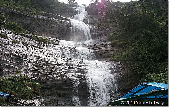
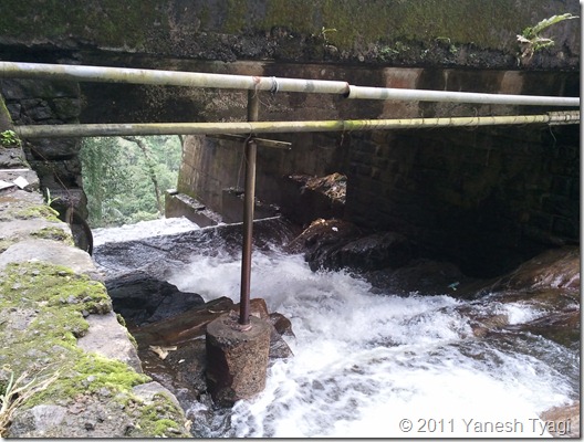
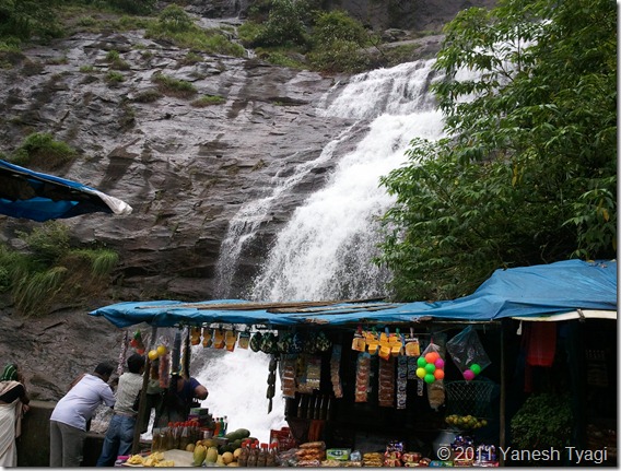
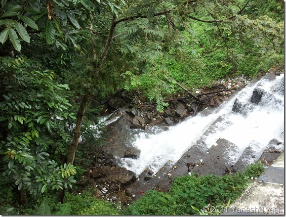
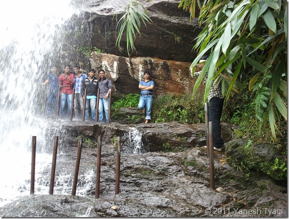
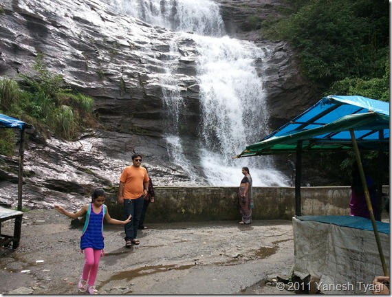
Cheeyappara waterfall is one of the few waterfalls which you can view from the bottom. Also, there is an area set apart to take bath in the cool shower of natural water. Geographical facts : Latitude: 10.072 Longitude: 76.775 Google Map: Directions from Ernakulum, Cochin - http://goo.gl/2ahMP Google Map: Satellite view of Cheeyappara waterfall - http://goo.gl/WT9YZ Related Links: My experience at Cheeyappara Waterfall Viewing a waterfall from the bottom Taking a shower at Cheeyappara Waterfall Mini Market @Cheeyappara Waterfall Water flows down the NH-49 Tags Technorati Tags: Cheeyappara Waterfall , Munnar , Kerala , India , Travel , Waterfall , Yanesh Tyagi 43 Things Tags: Cheeyappara Waterfall , Munnar , Kerala , India , Travel , Waterfall , Yanesh Tyagi del.icio.us Tags: Cheeyappara Waterfall , Munnar , Kerala , India , Travel , Waterfall , Yanesh Tyagi

Cheeyappara waterfall - one of the rare falls which you can see from bottom

Image
Cheeyappara waterfall - one of the rare falls which you can see from bottom. In this picture: Yanshi - My lovely kid, dear friend Gopal. Gopal’s Mom is admiring the waterfall. Click here to read details about the waterfall. Geographical facts : Latitude: 10.072 Longitude: 76.775 Google Map: Directions from Ernakulum, Cochin - http://goo.gl/2ahMP Google Map: Satellite view of Cheeyappara waterfall - http://goo.gl/WT9YZ Related Links: My experience at Cheeyappara Waterfall Viewing a waterfall from the bottom Taking a shower at Cheeyappara Waterfall Mini Market @Cheeyappara Waterfall Water flows down the NH-49 Tags Technorati Tags: Cheeyappara Waterfall , Munnar , Kerala , India , Travel , Waterfall , Yanesh Tyagi 43 Things Tags: Cheeyappara Waterfall , Munnar , Kerala , India , Travel , Waterfall , Yanesh Tyagi del.icio.us Tags: Cheeyappara Waterfall , Munnar , Kerala , India , Travel , Waterfal